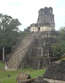
During the summer of 1981, Jeanne and I drove through the mountains
and jungles of Yucatan, Belize, Guatemala, Oxaca, and Campeche, the cradle of the great Mayan civilization. The Mayans
also built pyramids and looked to the stars. The Mayan calendar and their astronomy, specifically the calulation
of sun-moon events and seasons, are amazingly accurate by modern standards.
|
|
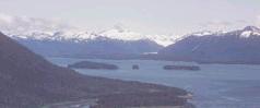
One of the major
features of southeastern Alaska is the Stikine River, which flows through the southern portion of the Stikine-LeConte
Wilderness. The river valley is relatively narrow. The surrounding mountains are steep, rugged, and contain numerous glaciers.
Meltwater from these glaciers has a high silt content, giving the Stikine River a milky appearance. The river delta is highly
braided with three main navigable channels. Two warm and one hot springs are found along the river. North of the Stikine River
area is the LeConte Glacier, which flows into LeConte Bay. LeConte is the southernmost glacier in North America that flows
directly into salt water. Mountains in the area of LeConte Bay are steep and most of the upper valleys are glacier-filled.
Glaciers and ice fields cover most of the rugged, mountainous area in the eastern part of the Stikine-LeConte Wilderness. Alpine vegetation, including mosses, lichens, and other small plants, is found at the upper
elevations. The lower mountain slopes near salt water support a dense spruce-hemlock rainforest. Closer to the Canadian border,
the rain decreases and the vegetation changes to stands of cottonwood. Cottonwood are also common on the many islands of the
Stikine. The valley floor along the river is a combination of muskegs and dense alder and willow thickets. The Stikine River
delta is approximately 17 miles wide and consists of grass flats, tidal marsh, and sand bars. Much of the area,
particularly the Stikine River drainage, is recognized as an important fish and wildlife area. Moose, mountain goats, brown
bear and black bear, deer, and wolves inhabit the area. The delta flats of the Stikine River are a major resting and nesting
area for migratory birds. A variety of fish, including king and other species of salmon, are found in the waters of
the area. Up to 2000 eagles congregate in the mouth of the river, following a run of smelt.
|
|
 |
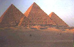
It's impossible to realize the immense size of the pyramids at Giza,
Eqypt from a picture. Each block is taller than a human being! Looking at the position and relative size of the
four Giza pyramids, it is easy to recognize the layout as a terrestrial representation of the constellation of Orion.
Specifically, the three main pyramids represent the position and size of the three main stars in Orion's belt. Interestingly,
one of the huge Nazca line drawings on a plain in Peru also represet Orion depicted as a "sky spider." What might these
global references to Orion in the human psyche tell us about the "seed" of the human race?
|
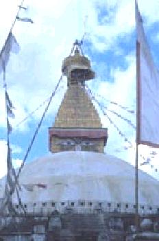
Bodhanath, Patan, and Swayambhumath (the Monkey Temple) are all easily
accessable from Kathmandu by bicycle. Getting to each on my own power was as much fun as being there. The stupas
represent a spiritual power that consumed me. The carvings on the temples in Patan are amazing. Be sure to "smile"
at the monkeys on the hill as you climb Swayambhumath. Their perception of your smile will be unexpected. Things
are never as they seem!
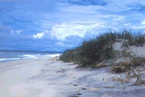
Assateague is a windswept barrier island that offers many opportunities
for seashore recreation and nature study along its thirty-seven miles. Ocean swimming, camping, bayside canoeing, crabbing,
clamming, hunting, surf fishing, and off-road vehicle use are all popular. The famous wild horses roam throughout and
share beach to bay habitats with a host of other animals, including over 300 species of birds
|
|